

READINGTON TOWNSHIP HISTORY
By Stephanie Stevens, Township Historian (1993)
July 15, 1730 was the official birth date of Readington Township. Created by Royal Charter as Readings, or Readings Town, it wasn’t until 1798 that it became Readington Township. Containing about 48 square miles, ours is the largest township in the County of Hunterdon and one of the largest in the State of New Jersey. We are bounded on the north by the rockaway Creek and the Lamington River, southerly by the south branch of the Raritan River, easterly by Somerset County and westerly by the “Society’s Great Tract” of some 92,000 acres of land owned by the proprietors of West Jersey. Our westerly border was the crest of Cushetunk Mountains and up the middle of Potterstown Road. This line was surveyed in 1711.
Our heritage is Dutch-German with the Dutch being the earliest and most populous. Original settlements of Dutch farmers took place in and around the village of Readington, where a mill was erected (circa 1710 – 1715) by Adrian Lane. By 1738 the Dutch Reformed Church of North Branch moved west to Readington, no doubt because of the greater number of members residing there. Today’s Readington Dutch Reformed Church replaces two earlier church buildings. As the population increased, a school was built; an inn and a store completed the Little Dutch Settlement. Readington Village is listed on the national Register of Historic Places. Remaining are five 18th century houses, a portion of the mill wall, the store, church and cemetery, inn, two school houses and several early 19th century houses.
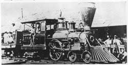 White House (inclusive of White House Station which came into being when the railroad came through in 1847) and Potterstown are also ancient communities. White House got its name from the Inn of Abraham Van Horne who came here in 1733. Van Horne’s Inn was located along an important Indian path and was the only place of rest for travelers for many miles. The building had white walls and eventually became known as “the White House”. The whole area took its name from the little pre-Revolutionary tavern.
Potterstown, another village on the National Register of Historic Places, competed with Readington for early settlers. It is in this tiny village that the “Society’s Line” crosses the important Raritan Indian Path. We know that Potterstown was a stopover for travelers early in the 18th century. This village appears on every map of ancient New Jersey. There were two taverns, a blacksmith shop, a store house and wheelwright and at sometime in the long distant past, a pottery. Owners of property included some of the most famous names in New Jersey history; William Alexander
 (The Lord Stirling of Revolutionary fame), John Stevens and Robert Livingston. The first German Lutheran Church building erected in the State of New Jersey was built here in 1729-1730 on land donated by a free black man named Aray Van Guinee. At this time in history of New Jersey, Aray Van Guinee was probably the most prominent black in the whole State. His sons went on to fight in the Revolutionary War. At the far end of Potterstown, up the rockaway Creek, is the mill of Colonel John Taylor, commanding officer of the 4th Hunterdon Militia. The miller’s house stands, too. Both were built in 1760 and both are on the National Register of Historic Places. Grain for the use of the Revolutionary Army was ground in this little mill. Our roots go deep in Potterstown.
Did you know that Stanton was first called Housel’s, then Waggoner’s Hill, then Mount Pleasant? Finally when the post office was established and there was already another Mt. Pleasant in Hunterdon, it became Stanton. Also on the National Register of Historic Places, Stanton was originally a settlement of German farmers stretched along the “Society’s Line” on large land holdings. Intermarriage with Dutch families and the fact that the nearest Lutheran Church had relocated to New Germantown (known as Oldwick today) made everyone Dutch. With Readington’s “Meeting House” also a great distance, a new Dutch Reformed Church was opened here in 1833. There had been a school in Stanton since the late 18th century and a store opened in 1838. Remaining are three stone houses built in the mid 18th century, a clapboard house vintage 1789, several early 19th century houses, a store, a church and many barns to remind us that everyone was once a farmer.
Tucked way over in the most southerly corner of the Township is Three Bridges and Centerville, both located on the Old York Road. During and before the Revolutionary War, Old York Road was one of the most important roads in the Colonies. Old York road connected the great cities of Philadelphia and New York. As a Swift Sure Stage Coach jolted and banged over this mud path on its way to the city, there was a place, a small inn, where an overnight stop was necessary for horse and passenger alike. The center point on the trip, it soon took on the name of “Centerville” and has kept it to this day. Just south on the road is another small town, Three Bridges. When the railroad went through the area in 1867, the town grew into a charming place filled with late 19th century homes.
While these quaint villages are scattered throughout Readington Township today, they were once small centers of church, school and commerce in a vast farming township. Loosely connecting these places were tiny hamlets bearing such names as Mechanicsville, Dreahook, Lewisburg, Farmersville, Stillwells – all descriptive of who lived and worked there. All have disappeared down the dusty paths of time. Readington’s historical roots are deeply entwined in the families that began this nation. We can be proud of our place in the founding of New Jersey and the United States.